
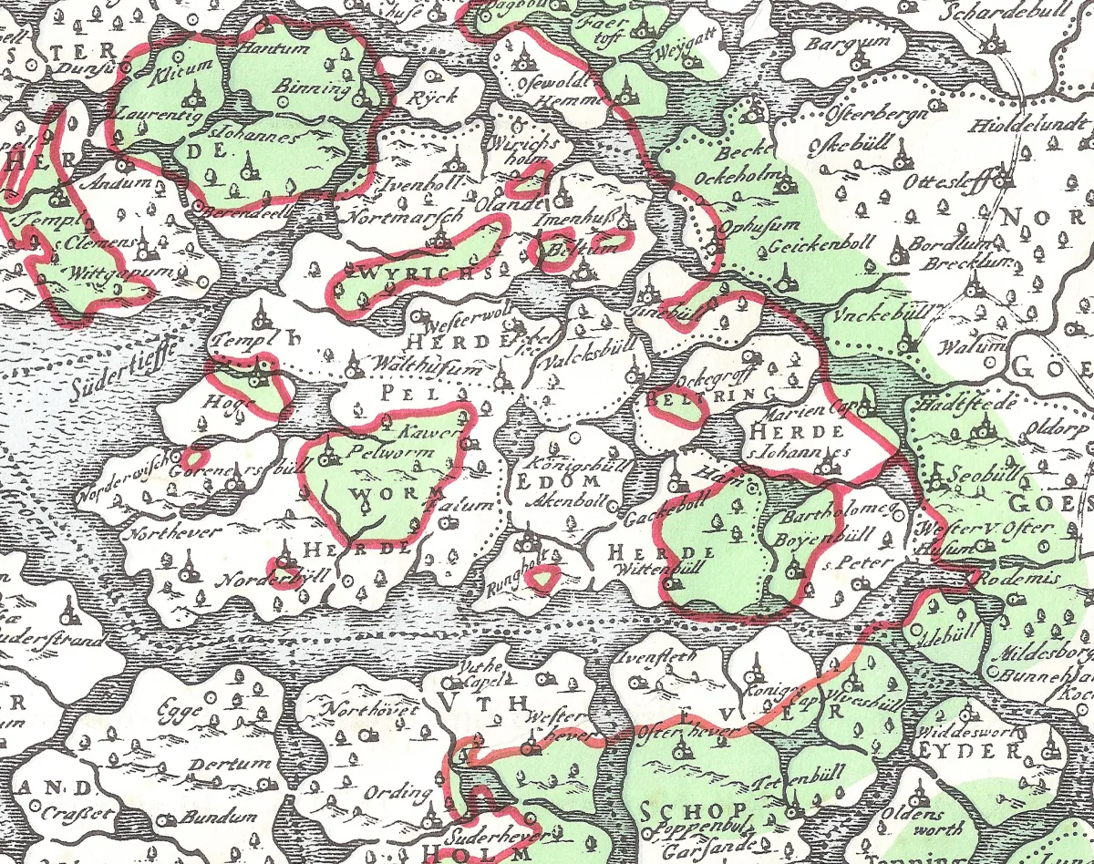
Somewhere in the tidal flats west of the Nordstrand peninsula in northern Germany, under two meters of sand at some points and barely twenty centimeters at others, lies the outline of a church that stopped being used on a January night in 1362. For roughly three hundred years, that church existed only as a story. For another hundred, it was a research question nobody could settle. In May 2023, a team pushing a magnetometer array across the mud at low tide finally found it.
The story of Rungholt is worth telling twice. Once as the legend that made it famous, and once as the far less operatic thing the evidence supports. The gap between the two is the interesting part.
The legend
The popular version runs like this. Rungholt was a wealthy trading metropolis, grown rich and arrogant. Its citizens forced a priest to give communion to a drunken pig, and beat him when he resisted. He prayed for punishment, was warned in a dream to flee to higher ground, and that night the sea took the city. Tens of thousands drowned. On certain days, the story goes, you can still hear the church bells under the water.
Almost none of this is medieval. The earliest written account of Rungholt's destruction appears in Anton Heimreich's Nord-Fresische Chronick, printed in 1666, three centuries after the event. Heimreich worked from documents now lost, and his account is demonstrably shaky: he dated the flood itself to 1300 rather than 1362. Reading a drowned town as divine judgment on sinners was the standard way to explain storm surges in his era, and flood legends of this type circulated attached to several North Sea locations before the name Rungholt got fixed to them.
The literary version arrived much later. Theodor Storm worked the material into a novella around 1871. Then Detlev von Liliencron, a district administrator on the nearby island of Pellworm, wrote the ballad Trutz, blanke Hans in the early 1880s. It is a good poem, and it did the historical record enormous damage. Liliencron gave Rungholt Babylonian dimensions: overflowing granaries, crowds like ancient Rome, exotic traders in the streets. He drowned a hundred thousand people in a single line.
"Atlantis of the North Sea" is a modern journalistic coinage layered on top of all that. It sells well. It is not a historian's term.
The poet who made Rungholt world-famous put it in the wrong place. Liliencron set his ballad at Rungholt Sand, a sandbank he passed on the steamer, where the town almost certainly never stood.
The paper trail
The contemporary record is thin, because the 1362 flood tore a gap into North Frisia's written sources as well as its coastline. Three documents carry most of the weight.
In 1345, the name Rungheholte appears in a letter sent from Hamburg concerning a will. On May 1, 1361, eight months before the flood, Rungholt signed a trade agreement with Hamburg merchants, so the place was still standing and commercially connected. And an income register of the Schleswig diocese from 1436 lists 24 churches and chapels in the region as permanently flooded since 1362. Rungholt is the only entry with both a main church and a collegium, a regional church assembly.
From this, historians place Rungholt as the church, court and administrative center of the Edomsharde, one of five districts on the old island of Strand, colonized under the Danish crown. Note what is missing: Rungholt was never a city in the legal sense. It held no town rights. It was a parish and an administrative seat, one node in the busy medieval trading world of the North Sea that Michael Pye describes in The Edge of the World * (affiliate link).
The flood
The storm surge usually dated to January 16, 1362 is known as the First Grote Mandränke, Low German for "great drowning of men." It swept the North Sea coast from Flanders through the Netherlands and Germany to Denmark and Britain. The death tolls quoted for it, 25,000 in some books, 100,000 in others, have no reliable medieval basis. They are early modern and modern estimates stacked on each other.
The land loss is well established, though. Large parts of North Frisia were never reclaimed. Fertile marshland became tidal flats and stayed that way, which is why the site can be surveyed today by walking across it at low tide.
A farmer and a sluice
In 1921, Andreas Busch, a farmer on Nordstrand and a self-taught researcher, found the remains of an old sluice in the mudflats near the islet of Südfall. Over the following seventeen years, the tides kept exposing more: dwelling mounds, building remains, the foot of a dike, wells, cisterns. The sea destroyed most of it again within a few years, but Busch documented everything first, and combined his field notes with old maps, geology and hydrology to argue that this was Rungholt.
Modern researchers regard his interpretations as broadly correct, while noting that his data was too thin for definitive proof. Academic history accepted the settlement's existence by the late 1930s. The name on the ruins stayed an open question for another ninety years.
The church under the mud
Since around 2015, a team from Kiel University, the University of Mainz, the Leibniz Centre for Archaeology and the Schleswig-Holstein State Archaeological Office has been surveying the flats with magnetometers, electromagnetic induction, seismics and sediment cores. Fieldwork happens in windows of two to four hours per day around low tide, before the sea returns. The comprehensive results were published in Scientific Reports in July 2024.
The picture that emerged: 64 artificial dwelling mounds across at least ten square kilometers, arranged in rows along drainage ditches, four settlement areas plus a harbor site, all inside one diked polder. And on a central mound, the foundation of a church roughly 40 by 15 meters. Dating puts the settlement in the 12th to 14th century. The finds include glazed pottery, bronze and brass cauldrons, swords, and faience from Moorish Spain. Rungholt was prosperous and connected.
The church mound itself has completely eroded away. What the magnetometers found is an imprint: the foundation trench dug down into the peat, and a 40-centimeter dent the building's weight pressed into the ground. The church survives as the shape of its own absence.
The church is the decisive find. In North Frisia, churches over 30 meters long are known only as the main churches of a district, which matches the Rungholt of the documents. And the size of the settlement allows a population estimate: roughly 1,000 to 1,300 people.
That number demolishes the legend more effectively than any argument about drunken pigs. Contemporary Lübeck had around 20,000 inhabitants. Rungholt was a substantial, well-connected rural parish center. A metropolis it was not, and a hundred thousand people could not have drowned in a place a thousand lived in.
The land drowned itself
Here is where the research says something the legend never could.
North Frisia's marshes were barely habitable for most of history. Systematic reclamation only began around 1100, and it worked, for about two centuries. Then the feedback loops closed. Draining the marsh makes the soil compact and sink. Cutting peat, for fuel and for salt production, lowers the surface further, on the evidence here probably down to the level of a normal high tide. And the dikes themselves, by taking away the water's room to spread, raised the storm surge levels outside.
The same techniques that made the land profitable made it drownable. The 1362 storm was the trigger, but the vulnerability had been manufactured over two hundred years by the people who lived there. That is a considerably more uncomfortable moral than "God punished the wicked," and unlike the legend, it generalizes.
The identification still rests on inference. The site matches the documents, the maps and the only main church in the area, but nothing found in the mud carries the name Rungholt. A strong case, not a nameplate.
A deadline in the mud
The researchers are unusually direct about the timeline. Around Südfall, the medieval remains are already so eroded that many survive only as negative impressions in the sediment, the imprint of a thing rather than the thing. Wind and waves are removing the rest. In 2024, the team found traces of 19 previously unknown dwelling mounds, so the map is still being redrawn while the site disappears.
The Wadden Sea is a UNESCO World Heritage site for its ecology. It is also one of Europe's most remarkable archaeological archives, and it is deleting itself. Rungholt survived six hundred years underwater. Another hundred looks unlikely.
The timeline
-
~1100
Systematic reclamation of the North Frisian marshes begins under the Danish crown. Dikes, drainage ditches, peat cutting.
-
1345
First surviving mention of the name Rungheholte, in a letter from Hamburg concerning a will.
-
1361
Rungholt signs a trade agreement with Hamburg merchants, eight months before the flood.
-
1362
The First Grote Mandränke, on the night usually dated to January 16, drowns Rungholt and large parts of the North Frisian coast.
-
1436
A church register lists 24 churches in the region as permanently flooded since 1362. Rungholt is the only entry with a main church and a collegium.
-
1666
Anton Heimreich prints the earliest surviving account of the legend, three centuries after the flood, with the wrong year in it.
-
1880s
Detlev von Liliencron's ballad Trutz, blanke Hans turns Rungholt into a drowned metropolis with a hundred thousand dead.
-
1921
Farmer Andreas Busch finds a medieval sluice in the mudflats near Südfall and starts documenting whatever the tides expose.
-
2015
Geophysical surveys of the area begin, in two-to-four-hour windows around low tide.
-
2023
In May, the survey team finds the foundation of Rungholt's church, 40 by 15 meters, under the mud.
-
2024
The full results appear in Scientific Reports: 64 dwelling mounds, a harbor, and a population estimate of about 1,000 to 1,300 people.
Sources
- Wilken et al., Scientific Reports 2024: The discovery of the church of Rungholt
- Hadler et al., Quaternary International 2018: Geoarchaeological evidence of marshland destruction in the area of Rungholt
- Wilken et al., PLOS ONE 2022: Lost in the North Sea?
- Kiel University press release, May 2023: Lost since 1362
- Kiel University / ROOTS, June 2024: The first comprehensive picture of Rungholt
- University of Mainz press release, May 2023
- Nordfriisk Instituut: Nordfriesland-Lexikon, entry Rungholt
- Panten, A. & Newig, J. (eds., 2016): Rungholt – rätselhaft und widersprüchlich. Husum.
- Heimreich, A. (1666): Nord-Fresische Chronick. Schleswig.
*Affiliate link. As an Amazon Associate I earn from qualifying purchases.